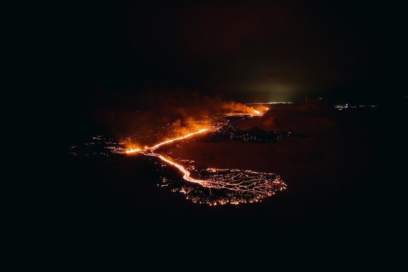
Ongoing eruption and a map from the MET office

An eruption started on the evening of the 18th of December at Sundhnúksgígar craters on the Reykjanes peninsula. This marks the fourth eruption in our region in three years.
The Reykjanes region is getting well-acquainted with volcanic activity, having experienced three previous eruptions in 2021, 2022, and summer 2023. Icelandic authorities and the public are thoroughly prepared for such events, and the country boasts some of the world's most sophisticated volcanic preparedness protocols. Iceland's geoscientists are also extensively experienced in monitoring volcanic activity.
The area around the eruption site and Grindavík is still closed. However, travelers can visit all other areas on the peninsula.
Updated information from the Icelandic MET office from December 20:
The eruption still shows evidence of it getting weaker. It has gone from erupting in fissures (up to 4 km long) to erupting in two craters today. The map below shows where the craters are located and the new lava field. Most of the lava is now flowing towards the east and it looks like it has stopped flowing towards the south.
While the eruption continues at Sundhnúksgígar, there is a likelihood that more vents may open along the original fissure as well as further north or south. Looking back at the precursors to the eruption, there were approximately 90 minutes between the first indicators and the start of the eruption. Therefore, the warning time for new vent openings at Sundhnúksgígar could be very short. For that reason, the area is still closed, and it is inaccessible to visitors.

Please take note of the following and the links below for further information:
- The eruption site is closed and therefore hiking in the area is prohibited. Please respect the closures and follow the instructions of the authorities.
- The eruption is best viewed online with a live feed on the media sites mbl.is and ruv.is or from viewing sites from the towns of Reykjanesbær and Vogar.
- The eruption is at the moment at a safe distance from the town of Grindavik and other structures. It does not pose an immediate threat to people, and no additional evacuations are necessary at this time.
- The highway Reykjanesbraut (no. 41) is open and operating as usual and the international airport in Keflavík is functioning normally. All flights are currently operating on schedule. The impact of volcanic eruptions tends to be limited to specific, localized areas near the eruption site. Notably, previous eruptions in the area did not impact international or domestic air travel.
Useful links to monitor and review updates on the events:
- The Icelandic MET office: Latest information on the seismic activity and development of events. The Icelandic Meteorological Office is observing and monitoring the eruption, analyzing developments and updating on any changes in cooperation with the Department of Civil Protection and Emergency Management and a team of scientists from the University of Iceland.
- Iceland Ministry for Foreign Affairs: FAQ regarding flights and other info
- The Icelandic Road Administration: Information on road conditions and closures in the Reykjanes region
- Safetravel: Updates on safety
- The Icelandic National Broadcasting Service: News coverage
- Visit Reykjanes: Updates on travel information in the Reykjanes region
